

A soil survey describes the characteristics of the soils in a given area, classifies the soils according to a standard system of classification, plots the boundaries of the soils on a map, and makes predictions about the behaviour of soils.
The different uses of the soils and how the response of management affects them are considered. The information collected in a soil survey helps in the development of land-use plans, evaluates and predicts the effects of land use on the environment.
Read Also: Collection, Handling, Storage and Pre-Treatment of Seeds
Understanding the Soil Profile in Agriculture
You might ask what a soil profile is. A profile is a side view of a person. So a soil profile must be the side view of soil. There are no fixed number of horizons a soil profile would much depend on the age and weathering processes going on in the soil. A soil could have the following horizons for example:
1. O Horizon (1st layer): This is the top layer of soil. Animals live on this layer. It is made of fresh to partially decomposed organic matters. The colour varies from brown to black.
2. A Horizon (2nd layer): The top part of this soil is made of highly decomposed organic matter mixed up. The colour ranges from brown to gray.
3. E Horizon (3rd layer): This layer is made up of mostly sand and silt due to downward migration of particles; it has lost most of its minerals and clay due to eluviation.
4. B Horizon (4th layer): Unlike the other horizons, this one has more clay and bigger bedrock. It is reddish brown or tan in colour.
5. C Horizon (5th layer): This layer has mostly weathered bedrock. It is the cracked and broken surface of the bedrock.
6. R Horizon (Last Layer): This is the last layer in the profile. It is made of unweathered rocks.
Detailed Soil Profile Description for Agricultural Use
Soil Profile refers to the layers of soil: horizon A, B, and C. Horizon A refers to the upper layer of soil, nearest the surface. It is commonly known as topsoil. In the woods or other areas that have not been plowed or tilled, this layer would probably include organic litter, such as fallen leaves and twigs.
The litter helps prevent erosion, holds moisture, and decays to form a very rich soil known as humus. Horizon A provides plants with nutrients they need for a great life.
The layer below horizon A is the B. Litter is not present in horizon B and therefore there is much less humus. Horizon B does contain some elements from horizon A because of the process of leaching.
Leaching resembles what happens in a coffee pot as the water drips through the coffee grounds. Leaching and, in the case of cultivated soil, soil mixing may also bring some minerals from horizon B down to horizon C.
If horizon B is below horizon A, then horizon C must be below horizon B. Horizon C consists mostly of weathered big rocks. This solid rock, as you discovered in Soil Formation, gave rise to the horizons above it. Soil profiles look different in different areas of the world. They are affected by climate and other things.
Soils are structural and functional elements of terrestrial ecosystems, which are formed in a historical process of development through the interaction of geological, climatic, and biotic factors at the respective site.
Soil is the fundamental source of life for all living beings. As the physical and chemical properties of soils exert great influence in the distribution and development of vegetation, it needs to be studied and evaluated from time to time.
The soil-forming process is very slow and time-consuming. It takes normally thousands of years for the soil formation. Therefore, we are studying the past activities while analysing the soil profile at present.
The parent material, topography, geological processes, climatic conditions, vegetation, and human interferences play major roles in the formation and development of soil profiles in a particular area. Similarly, our activities at present will certainly influence the soil profiles in the far future.
Geological factors include the type of parent material and its mineral composition, the relief of the area, its exposition, and the groundwater regime.
Climatic factors include the level of solar radiation, precipitation, humidity, air temperature, and wind speed and the characteristics of the hydrological regime that result from these factors. Soils are affected by human activities, such as industrial, municipal, and agriculture, that often result in soil degradation and loss or reduction in soil functions.
In order to prevent soil degradation and to rehabilitate the potential of degraded soils, reliable soil data are the most important prerequisite for the design of appropriate land-use systems and soil management practices as well as for a better understanding of the environment. This is the main objective of soil science.
Read Also: Methods of Castration in Sheep and Goat
Soil Types and Their Agricultural Significance
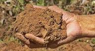
Sand, silt, and clay are the basic particles in a soil. Most soils are made up of a combination of the three. The texture of the soil, how it looks and feels, depends upon the amount of each particle in that particular soil. The type of soil varies from place to place on our planet and can even vary from one place to another in your own backyard.
Soil Conservation Practices in Agriculture
Soil erosion, caused by wind and rain, can change land by wearing down mountains, creating valleys, making rivers appear and disappear. It is a slow and gradual process that takes thousands, even millions of years.
But erosion may be sped up greatly by human activities such as farming and mining. Soil develops very slowly over a long period of time but can be lost very quickly.
The clearing of land for farming, residential, and commercial use can quickly destroy soil. It speeds up the process of erosion by leaving soil exposed and also prevents development of new soil by removing the plants and animals that help build humus.
Today’s farmers try to farm in a way that reduces the amount of erosion and soil loss. They may plant cover crops or use a no-till method of farming. Soil is an important resource that we all must protect. Without soil, there is no life.
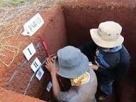
Conducting a Soil Survey for Agricultural Planning
Soil survey, or soil mapping, is the process of classifying soil types and other soil properties in a given area and geo-encoding such information. It applies the principles of soil science, and draws heavily from geomorphology, theories of soil formation, physical geography, and analysis of vegetation and land use patterns.
Primary data for the soil survey are acquired by field sampling, supported by remote sensing, (principally aerial photography).
Sample of an Aerial Photo from a Published Soil Survey
The term soil survey may also be used as a noun to describe the published results. In the United States, these surveys have been published in book form for individual counties by the National Cooperative Soil Survey.
The information is used by farmers and ranchers to help determine whether a particular soil type is suited for crops or livestock and what type of management might be required. An architect or engineer might use the engineering properties of a soil to determine whether or not it was suitable for a certain type of construction.
Components of a Soil Survey Report for Agricultural Use
Typical information in a published soil survey report includes the following:
- A brief overview of the county’s geography
- A general soil map with a brief description of each of the major soil types found in the area along with their characteristics
- Detailed aerial photographs with specific soil types outlined and indexed
- Photographs of some of the typical soils found in the area
- Tables containing general information about the various soils such as total area, comparisons of production of typical crops and common range plants. They also include extensive interpretations for land use planning such as limitations for dwellings with and without basements, shallow excavations, small commercial buildings, septic tank adsorptions, suitability for development, construction, and water management.
- Tables containing specific physical, chemical, and engineering properties such as soil depth, soil texture, particle size and distribution, plasticity, permeability, available water capacity, shrink-swell potential, corrosion properties, and erodibility.
A soil survey report should carry or contain information that is specific to a given form of land use. This is usually determined by the Terms of Reference (TOR) after survey.
Do you have any questions, suggestions, or contributions? If so, please feel free to use the comment box below to share your thoughts. We also encourage you to kindly share this information with others who might benefit from it. Since we can’t reach everyone at once, we truly appreciate your help in spreading the word. Thank you so much for your support and for sharing!