
A soil mapping article is a collection of areas defined and named the same in terms of their soil components or miscellaneous areas or both. Each article differs in some respect from all others in a survey area and is uniquely identified on a soil map. Each individual area on the map is a delineation.
Soil Survey for Agricultural Applications
The term soil survey may also be used as a noun to describe the published results. The information is used by farmers and ranchers to help determine whether a particular soil type is suited for crops or livestock and what type of management might be required.
An architect or engineer might use the engineering properties of a soil to determine whether or not it was suitable for a certain type of construction.
Read Also: Cold Weather Poultry Diseases and How to Manage them
Components of Soil Survey Reports

Typical information in a published soil survey includes the following:
- A brief overview of the area’s geography
- A general soil map with a brief description of each of the major soil types found in the area along with their characteristics
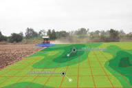
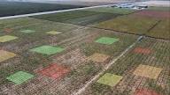
- Detailed aerial photographs with specific soil types outlined and indexed
- Photographs of some of the typical soils found in the area
- Tables containing general information about the various soils such as total area, comparisons of production of typical crops and common range plants. They also include extensive interpretations for land use planning such as limitations for dwellings with and without basements, shallow excavations, small commercial buildings, septic tank adsorptions, suitability for development, construction, and water management.
It should be noted that a particular soil survey report would carry information relative to the use of the soil as contained in the Terms of Reference (TOR).
This means that a report intended for agricultural use would focus on agronomic soil data as compared to the report meant for engineering purposes which could develop more on engineering properties as outlined above.
Tables containing specific physical, chemical, and engineering properties such as soil depth, soil texture, particle size and distribution, plasticity, permeability, available water capacity, shrink-swell potential, corrosion properties, and erodibility.
Read Also: Layers or Broilers which One is More Profitable in Poultry Farming? Find Out!
Soil Mapping as a Pillar of Sustainable Agriculture
There is a need for accurate, up-to-date, and spatially referenced soil information. This need has been expressed by the modeling community, land users, and policy and decision makers. This need coincides with an enormous leap in technologies that allow for accurately collecting and predicting soil properties.
Do you have any questions, suggestions, or contributions? If so, please feel free to use the comment box below to share your thoughts. We also encourage you to kindly share this information with others who might benefit from it. Since we can’t reach everyone at once, we truly appreciate your help in spreading the word. Thank you so much for your support and for sharing!