
Information on both gross and net erosion rates from agricultural land is essential for determining the sediment delivery ratio (SDR) the proportion of sediment mobilised by soil erosion that reaches nearby watercourses instead of being deposited near its source.
For this reason, soil productivity relationship and modeling was developed to assess and manage erosion risks, and to support informed decisions in soil conservation and agricultural productivity planning.
Variables and Functions in Agricultural Soil Erosion Modeling
A comprehensive farm-level soil conservation model should include the following variables and functions:
- Functional relationships that reflect the effect of farm management choices (control variables) on soil properties (state variables), acting as state equations in an optimal control framework.
- State variables that track changes in soil depth and other characteristics linked to productivity.
- Erosion-productivity linkages that connect changes in soil attributes to crop yields.
- Crop yield functions that integrate both soil productivity and management variables, Soil Productivity Relationship and Erosion Modeling in Agriculture highlighting the trade-offs between soil use and other inputs within the model.
Read Also: Cutworms: How to Identify and Get Rid of Cutworms
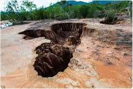
Measuring and Quantifying Soil Erosion on Arable Agricultural Land

Traditional monitoring techniques for assessing erosion rates often fail to determine the ultimate fate of eroded sediments. These methods typically do not indicate the impact on surface water quality and struggle to describe spatial erosion and deposition patterns or SDR across landscapes.
Much data on erosion has come from flume and erosion plot studies, which mainly show net soil loss at a specific lower boundary.
However, these plots often overestimate erosion because they overlook sediment storage in catchment areas, especially in flat regions like valley bottoms. As catchment size increases, such storage areas become more prominent.
As erosion studies move from plot to field and catchment scale, the influencing factors and appropriate measurement techniques also change.
At larger scales, sediment fingerprinting and composite fingerprinting are preferred for identifying sediment sources and estimating erosion impacts more accurately.
Erosion Modeling as a Predictive Tool in Soil Conservation
Soil erosion modeling serves as both a predictive and simulative tool in analyzing soil loss processes. These models account for soil detachment, transport, and deposition, relying on transport capacity the maximum amount of sediment flow can carry without deposition.
Erosion models are widely used for generating hazard data for land conservation and agricultural land management. There are three main categories of erosion models:
- Empirical models
- Conceptual models
- Physically-based models
These models typically use ordinary differential equations to describe changes in erosion. All three models share structural similarities and rely on four core factors: climate, topography, vegetation cover, and soil type.
Models differ in how they simulate surface modification during erosion events and whether they offer continuous simulations or single-event predictions.
Accurate soil erosion estimation remains limited due to two factors: model uncertainty and variability in space and time. Even calibrated models may fail to predict accurately when conditions fall outside calibration ranges.
Moreover, the quality of input data greatly affects the performance of more complex physically-based models, which may not outperform simpler regression-based models if data quality is poor.
Empirical and Conceptual Models in Agricultural Erosion Assessment
- Empirical model rely primarily on observed data and are often statistical in nature. They use inductive reasoning and are typically only reliable when calibrated to specific local conditions. Their main role is to predict average soil loss. Variants include:
- Black-box models, which focus only on input and output.
- Grey-box models, which offer some insight into system processes.
- White-box models, which fully detail the system’s inner workings.
Examples include USLE, RUSLE, and RMMF. A key limitation of empirical models is their limited transferability across different regions or conditions.
Conceptual models fall between empirical and physically-based models. They use simplified forms of water and sediment yield, often applying the unit hydrograph concept to estimate runoff and erosion at catchment scale.
Read Also: Causes of Diseases in Farm Animals and How to Prevent Disease OutBreak
Physically-Based Models for Erosion Simulation in Agriculture

To evaluate off-site erosion effects and non-point source pollution, physically-based models have been developed. These models are useful across various scales, from individual plots to large watersheds.
Physically-based (or process-based) models use mathematical equations to represent erosion processes. These models capture the complex interactions between erosion factors and their spatial and temporal changes.
Examples include:
- ANSWER
- CREAM
- WEPP
- PESERA
These models offer detailed simulations but demand high-quality, extensive input data. Their use is best justified where such data are available and the complexity can be managed.
Universal Soil Loss Equation (USLE) and Its Applications
The Universal Soil Loss Equation (USLE) is an empirical, grey-box model developed at the National Runoff and Soil Data Center with Purdue University. It estimates average annual soil loss from inter-rill and rill erosion, based on:
A = RKLSCP
Where:
A = average annual soil loss
R = rainfall erosivity
K = soil erodibility
L = slope length
S = slope gradient
C = cropping management
P = conservation practices
USLE was derived from over 25 years of field research and more than 10,000 plot-years of data. Although widely used, USLE does not account for gully erosion or sediment deposition, providing only gross erosion estimates.
Modifications of USLE for Agricultural Applications
1. MUSLE (Modified USLE): Estimates sediment yield from specific runoff events. It replaces R with a runoff-energy factor:
Rw = 9.05 × VQp⁰·⁵⁶, where V is runoff volume (m³), and Qp is peak discharge (m³/s).
2. RUSLE (Revised USLE): A computer-based version that refines factor estimation. Like USLE, it excludes channel erosion and sediment deposition.
3. ANSWERS: Simulates runoff and erosion in agricultural watersheds, addressing detachment by raindrops, overland flow, and sediment transport. It incorporates USLE’s K and CP factors and can simulate both erosion and deposition.
4. AGNPS: An event-based model for small to medium agricultural watersheds (up to 200,000 ha), using a modified USLE to simulate runoff, sediment, and nutrient transport.
5. CREAMS: Estimates sediment yield from storms in small agricultural watersheds, also using USLE parameters.
6. WEPP: A watershed-scale model by USDA-ARS designed to overcome USLE limitations. It has primarily been tested in rangeland areas in the USA and requires extensive data input (over 20 variables), unlike USLE which needs only six.
Despite the development of advanced models, USLE remains widely used due to its simplicity and relatively low data requirements.
Do you have any questions, suggestions, or contributions? If so, please feel free to use the comment box below to share your thoughts. We also encourage you to kindly share this information with others who might benefit from it. Since we can’t reach everyone at once, we truly appreciate your help in spreading the word. Thank you so much for your support and for sharing!